This project has been archived and is no longer being updated.
Working to make our community safer
The City of North Vancouver is working with the District of North Vancouver on a number of roadway improvements to improve safety along East 29th Street between Lonsdale Avenue and Lynn Valley Road. This project is being delivered in two phases:
Phase 1: Implemented in 2019, this phase focused on the area from Regent Avenue to Lynn Valley Road. Improvements included new sidewalks, traffic lights, left turn lanes and a protected bike lane.
Phase 2: Focuses on the area from Lonsdale to Regent Avenue. Work will focus on paving, roadway markings, intersection safety, sightline improvements, and adjustments to transit stop locations.
View the Design
The complete corridor design is available below. Community input is also summarized below under three common themes: speeding, visibility and shortcutting. Under each theme, the City has identified what we heard from you and how that feedback has been reflected in the design.
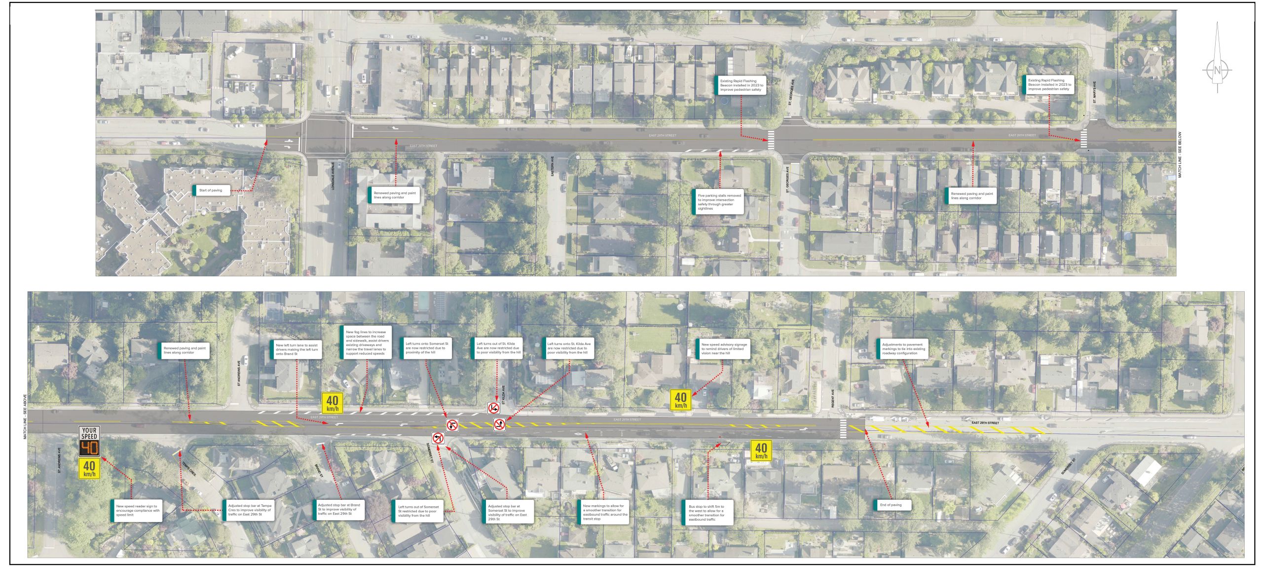
Summary of Findings
Click through the following headers to learn more about each sub-theme.
What We Heard:
- Speeding along East 29th Street is a concern for pedestrians, cyclists and drivers.
How We Are Responding:
- Reducing travel lane widths so they are appropriately sized for an arterial road.
- Periodically installing a digital speed reader to provide speed feedback to drivers and remind them of the posted speed limit.
- Continuing our partnership with RCMP on speed enforcement.
What We Heard:
- Visibility is a concern at various locations along East 29th Street due to parked vehicles, overgrown vegetation and the steep hill.
- Turning onto East 29th Street from some side streets can be challenging, especially near the hill.
How We Are Responding:
- Adding ‘fog lines’ to help drivers safely pull out from driveways to see oncoming traffic.
- Restricting left turns in and out of St Kilda Avenue and Somerset Street due to proximity of the hill.
- Adding a dedicated left turn lane onto Brand Street to assist drivers in making this turn.
- Removing 5 parking spaces on the south side of East 29th Street at St Georges to improve visibility.
- Pruning trees and vegetation to improve sightlines.
What We Heard:
- Shortcutting is an issue on St Georges Avenue and other side streets, especially during rush hour when there is increased traffic on East 29th Street.
- The addition of a dedicated left turn lane at St Georges Avenue would further encourage vehicles to use this route.
How We Are Responding:
- A dedicated left turn will not be added at St. Georges Avenue at this time. The Upper Levels Greenway project will look at broader vehicle travel patterns in this neighbourhood, including options to address shortcutting on local streets.
- The District of North Vancouver is conducting a safety study along Lonsdale from 29th Street to the north. Data collected from this study will be used to make broader changes to the Lonsdale corridor in the future, which may include the Lonsdale and 29th Street intersection.
Next Steps
Construction is expected to begin in mid-late July 2024 and take approximately 2 weeks to complete. Advance notice will be provided to residents prior to any work beginning and construction updates will be available on the project webpage at cnv.org/East29th. We welcome your questions and comments at e29@cnv.org.


