Category #archive Show all
-
2023 Engagement Background
Share 2023 Engagement Background on Facebook Share 2023 Engagement Background on Twitter Share 2023 Engagement Background on Linkedin Email 2023 Engagement Background linkThe City of North Vancouver is working with the District of North Vancouver on the second and final phase of roadway improvements along East 29th Street. Phase 2 improvements will address the poor pavement conditions between Lonsdale Avenue and Regent Avenue and provide us with an opportunity to provide a safer, more comfortable experience for all road users. Work will focus on paving, roadway markings, intersection safety, sightline improvements and adjustments to transit stop locations. Bike lanes are not planned as part of this work as an alternate bike route is located along Tempe Crescent and 27th Street.
As a significant amount of time has passed since the first phase of engagement, we are reconnecting with residents to review areas along the corridor and share changes we are investigating. We’d also like to learn more about how residents are experiencing the street to help us identify any gaps.View the Corridor – Lonsdale Avenue to Regent Avenue
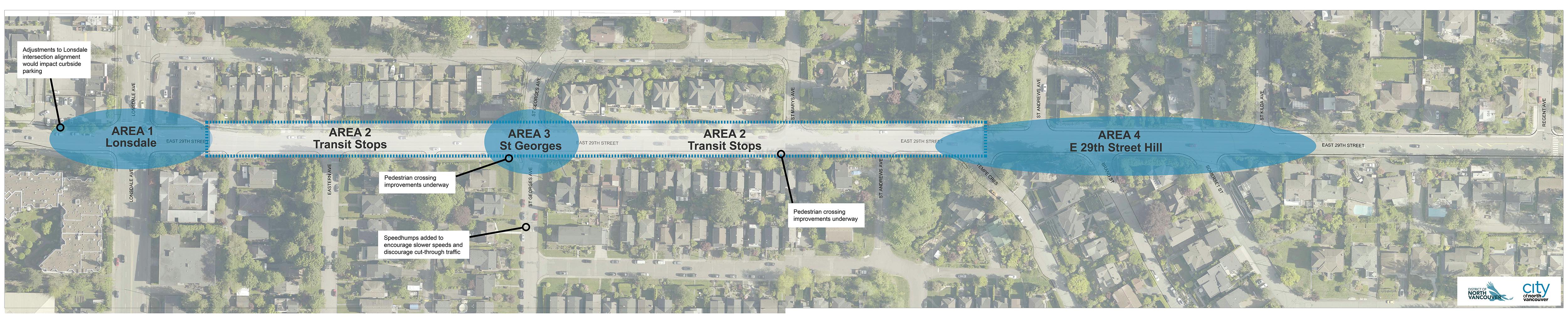
We’ve identified a number of areas along the corridor where we can improve the safety and comfort of road users. These areas were identified during the first phase of engagement, through ongoing communication with residents, observations made by City staff and recent data collection. The maps below provide information about changes we are investigating.
 [ Click to view larger ]
CORRIDOR WIDE IMPROVEMENTS:
Vehicle speeds along East 29th have been a key issue identified for resolution. The following measures are proposed to encourage compliance with the speed limit:- Reduced travel lane widths that are appropriately sized for the posted speed limit of 50km/h.
- Digital speed readers to be periodically installed along the corridor to remind drivers of the speed limit.
- Continued partnership with RCMP on enforcement.
Residents with driveways facing East 29th identified visibility challenges when exiting driveways.
- Painted buffer zones westbound from St Andrews to Somerset and eastbound from St Marys to Regent will improve sightlines by allowing drivers to pull out further to see oncoming traffic.
View Area Maps
We have provided additional information about each area highlighted on the corridor map above. Click the button below to learn more.

Project History
This project is being delivered in two phases. Phase 1, led by the District of North Vancouver, was completed in 2019 and focused on the area from Regent Avenue to Lynn Valley Road.
We are now in Phase 2 of the project, which focuses on the area from Lonsdale to Regent Avenue. A proposed design for Phase 2 was created in 2019, with work planned for 2020, but was postponed due to the impacts of COVID-19. Learn more about previous phases of engagement.
How You Can Get Involved
Between November 8 – December 1 2023, you can:
- Learn more by visiting the project webpage at cnv.org/East29th.
- Place pins on the map and tell us about a specific location along the corridor by dropping a pin and leaving a comment.
-
Attend the Open House to learn more about the project and share your input with staff.
- North Lonsdale United Church (3380 Lonsdale Avenue) | Wednesday, Nov. 15 | 6pm – 8pm
- Ask us a question about the project.
- Subscribe for email updates by entering your email in the Stay Informed box in the top right sidebar of this page.
- Contact staff with comments or questions at e29@cnv.org.
How Your Input is Used
The input you share about your experience travelling along this section of East 29th Street will help us make decisions about future roadway improvements. Community input will be considered along with City policy, industry standards and physical constraints of the roadway.